Precision Crop Load Management at WSU Smart Apple Orchard Testbed
Industry partners: Innov8.Ag Pvt Co. with Green Atlas Pty Ltd., Vivid Machines Inc., Tyton Aviation Pvt Co. with Outfield Technologies Ltd., Precision Agri Tech, Aurea Imaging
WSU Team: Juan Munguia, Prasanna Medarametla, Dattatray Bhalekar, Lav Khot, Bernardita Sallato
The details of crop parameters mapping technologies explored at smart orchard testbed are as follows. Most of these technologies map blossom count, fruit count and size attributes at variable units (per tree/feet/panel).
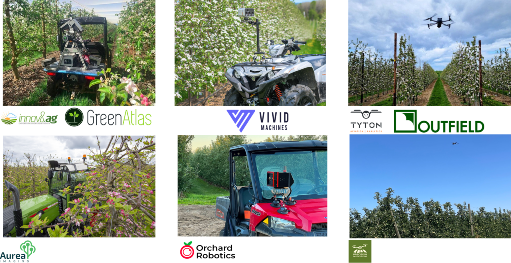
Innov8.Ag (Innov8.Ag Pvt Co., United States) uses Green Atlas Cartographer (Green Atlas Pty Ltd., Australia), a commercial sensing platform equipped with multiple sensors, including a 2D-LiDAR, high resolution RGB cameras with strobe lights, and GPS receiver. These hardware and machine learning algorithms are integrated and mounted on an all-terrain vehicle which can be driven at 5.6 m/s to collect ground-based imagery data. Pertinent data is post-processed using proprietary algorithms to generate the variability maps of estimated crop parameters. Innov8.Ag can provide these estimates in the top and bottom canopy sections at tree level resolution. The data can be used to estimate additional parameters such as bud count, canopy vigor, and fruit color.
The Vivid XV3 Vision System (Vivid Machines Inc., Canada) comprises a multispectral sensor capturing multiple bands in visible and near-infrared (VISNIR) spectral range, a GPS receiver, and an integrated proprietary data processing algorithm. This ground-based imagery system can be universally mounted on any farm vehicle with 2.2-4.5 m/s travel speed. The vision system can scan up to 20,000 trees/hour, processing and providing real-time insights. The system generates a variability map of estimated crop parameters at a tree-level resolution. The variability maps, data, and scanning reports can be accessed remotely using a smartphone or tablet installed with the Vivid Control app and cloud-based dashboards.
The Tyton Aviation (Tyton Aviation Pvt Co., United States) and Outfield Technologies (Outfield Technologies Ltd., England) collaboration uses an unmanned aerial vehicle (Mavic 3 Enterprise Multispectral, DJI Technologies) equipped with an integrated, gimbaled RGB (CMOS Hasselblad 20MP, DJI Technologies; resolution: 5280×3956 pixels) and multispectral (bands: Green, Red, Red-Edge, and Near-Infrared) sensors. During the flight campaigns at the smart orchard, the UAV was flown at an altitude of 7.6 m AGL and 5 m/s forward speed with 45° sensor orientation, providing a complete side-view of the tree from trunk to top. These flight parameters allow users to collect aerial imagery data at 16.2 ha/h which is post-processed using proprietary machine vision and deep learning algorithms to create variability maps. Outfield Technologies processes the acquired raw data using proprietary computer vision algorithms to create an orchard-specific variability map. The algorithm is capable of detecting fruits even in fields with overhead netting. For most applications, this technique generates maps of average estimated crop parameters, displayed in a 5×5 m grid, based on sampling 60% of the trees. However, this technique can also generate tree-level data with 100% tree coverage for tree-level blossom or fruit-thinning applications.
Precision Agri Tech (Precision Agri Tech LLC, United States)is a Washington‑based ag‑technology company delivering drone‑enabled, per‑tree orchard intelligence for fruit growers. Using FAA‑certified UAV flights, the company captures high‑resolution RGB and infrared imagery, georeferenced with RTK GNSS for inch‑level accuracy. Advanced computer vision and AI models process imagery to generate tree‑level metrics, including fruit count, size, color, and spatial inventory. These outputs are delivered through Treelytics, a patent‑pending in‑field mobile app that enables tree‑specific inspection, temporal trend analysis from repeat scans, and data‑driven decisions for crop load management, yield forecasting, and harvest labor planning.
TreeScout, developed by Aurea Imaging, Netherlands, is a precision orchard management system that delivers individual‑tree intelligence using a tractor‑mounted sensor platform. The system integrates high‑definition 3D computer vision, AI‑based analytics, edge computing, and RTK‑GPS to scan trees while routine operations such as spraying, mowing, or spreading are performed. TreeScout generates tree‑level data layers including fruit and blossom counts, canopy structure, and vigor indices, which are processed in the cloud and returned as prescription maps. These outputs integrate directly with variable‑rate sprayers, pruners, and other orchard equipment, enabling accurate, per‑tree input management, reduced resource use, and improved yield and fruit quality.
Significant Findings
- Blossom mapping: Mean difference in cluster counts ranged from 21.7% to 37.2%.
- Fruit counting and sizing: Results are reliable at later growth stages; however, early‑season estimates tend to overestimate fruit count and underestimate fruit size.
- Mapping repeatability: High consistency observed, with <11% error in fruit count and <5% error in fruit sizing.
For technology-specific findings, please read pertinent publications below.
Next Steps
Beginning in the 2026 season, the WSU team will focus on integrating spray task maps generated by the vision systems, e.g. Outfield aerial scans into variable-rate nutrient application (team: Bernardita Sallato and Lav Khot) and on enabling precision blossom thinning (led by Innov8.Ag in collaboration with Gwen-Alyn Hoheisel and Lav Khot). The blossom thinning trial will use a Turbo-mist sprayer (from Slimline Mfg. and Burrows Tractors Inc.) retrofitted with a RedAnt spray retrofit kit (Reid & Verwey Ltd., South Africa). The precision nutrient management trial will use a variable-rate spreader with a RedAnt spray retrofit kit.
Publications
- Bhalekar, D., Munguia, J. Sallato, B., Khot, L. R. (2025). Vivid XV3 Vision System for Precision Crop Load Monitoring. Fruit Matters Newsletter.
- Bhalekar, D., Munguia, J. Sallato, B., Khot, L. R. (2025). Green Atlas Cartographer for Precision Crop Load Monitoring. Fruit Matters Newsletter.
- Bhalekar, D., Munguia de la Cruz, J., Sallato, B., Khot, L., Meyer, M., Hanrahan, I., & Schmidt, T. (2025). Digital technology for precision apple crop load monitoring in Washington orchards. Fruit Matters Newsletter.